New
September 26, 2011 The Okanogan PUD voluntarily surrendered its preliminary permit to build the Shankers Bend Dam on the Similkameen River. See CELP & Sierra Club News Release.
Overview
The Columbia River is among the most heavily dammed rivers on Earth. Despite this fact, in 2005, Washington State embarked on a new dam-building program for the Columbia River basin. Click here for an overview of the program. In 2007 Washington State gave $300,000 to Okanogan PUD to study a new dam on the Similkameen River.
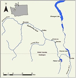
The Similkameen River is tributary to the Okanogan River, tributary to the Columbia River. The 156-mile-long river drains the east slope of the Cascade Mountains. Most of the 3,600 square mile watershed -- 90 percent -- is in Canada. The Similkameen River flows into the U.S. section of the Okanagan River south of Osoyoos Lake.
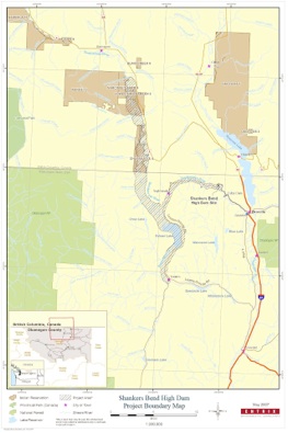
In 2007 Washington state taxpayers paid $300,000 to Okanogan PUD for studying a new dam at Shankers Bend on the Similkameen River. The new dam would flood Palmer Lake, extensive river habitat in both Canada and the USA, and abandoned mines and a Superfund site. The new dam is one of many dams proposed as part of the Columbia River Water Management Program (“CRWMP”, pronounced “kur whump”)
Proposed Dam
The study will focus on a range of dam heights between 90 and 240 feet. At the maximum dam height, the resulting reservoir would flood 18,000 acres, and hold 1.7 million acre-feet of water. Roughly one half of flooded land would be located in Canada.
To license the new dam the Okanogan Public Utility District No.1 (PUD) in May 2007 submitted its preliminary permit application with the Federal Energy Regulatory Commission (FERC). [PUD, Application For Preliminary Permit (2007)]
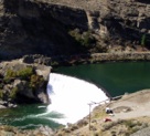
An existing dam currently obstructs the Similkameen River, located about 3.5 miles upstream from Oroville, Washington. The Okanogan PUD is also pursuing a FERC license for this dam. As the Hydropower Reform Coalition has written, “Enloe Dam was built for hydropower nearly a century ago. After project economics failed to pencil out, the project was closed in the 1950s. Since that time, the PUD has attempted to license the project twice, but in both cases rejected the license due to the federal reservation of authority for fish passage.
An existing dam currently obstructs the Similkameen River, located about 3.5 miles upstream from Oroville, Washington. The Okanogan PUD is also pursuing a FERC license for this dam. As the Hydropower Reform Coalition has written, “Enloe Dam was built for hydropower nearly a century ago. After project economics failed to pencil out, the project was closed in the 1950s. Since that time, the PUD has attempted to license the project twice, but in both cases rejected the license due to the federal reservation of authority for fish passage.
Canada
In Canada, the Shanker’s Bend Dam would flood about 9,000 acres of prime riverine habitat; in the United States, also about 9,000 acres. The reservoir threatens to flood substantial agricultural land around the township of Keremeos.
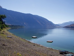
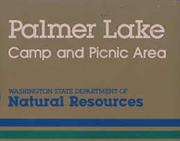
Palmer Lake
The lake would be flooded by a dam elevation in excess of 96 feet. The minimum dam height is 90 feet. Most of the land around Palmer Lake is privately owned -- lands that would be taken by eminent domain for the dam.
Palmer Lake covers 2,110 acres of surface area and holds 107,000 acre-feet of water. [Washington Department of Fish and Wildlife, Warm Water Fisheries Study, Palmer Lake (2005)]
In 1999, and again in 2005, the Washington Department of Fish and Wildlife (WDFW) completed a comprehensive study of the fishery. Fifteen species of fish were collected reflecting the diverse and successful management of warm water sport fishing resources within the lake.
Burbot, found in Palmer Lake, are a bottom-dwelling fish species and are the only freshwater member of the otherwise marine cod family (Gadidae). The fish is considered desirable by some sportsman. Burbot meat is delicate in texture and mild in flavor.
Flooding of Mining Sites
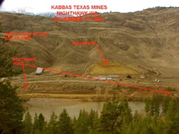
Okanogan County has a history of gold, lead, and silver mining that predominately occurred around Chopaka Mountain. The towns of Ruby and Nighthawk were the center of mining activities. Nighthawk was the location of the Kaaba-Texas Mine.
In 1991 the U.S. Environmental Protection Agency (EPA) collected soil and sediment samples from the Kaaba-Texas mine site. Sampling results showed that elevated concentrations of arsenic, cadmium, copper, lead, silver, cyanide and zinc remained in the Lower Bench tailings pile. Prompted by the results of the sampling, the EPA declared the Kaaba-Texas Mine a superfund site. In 1999 the EPA relocated 81,000 cubic yards of mine tailings from the edge of the Similkameen River to a location above the river. [E.P.A., Kabba-Texas Superfund Information sheet (2000)]
The Department of Natural Resources Inactive Mine Division has performed a preliminary survey on the number of sited impacted by a maximum project height. The agency concluded that 12 sites (including Ruby and Kabba-Texas) are located at or below the maximum full pool elevation.
A recent Ecology study released in June 2007 focused on the level of Arsenic in fish living in the Similkameen River and Palmer Lake. “This study was conducted to determine the potential of human health risk from consuming fish from the river. The Washington State Department of Health reviewed the results of the study and concluded that there is no risk to human health based on the consumption of inorganic arsenic in fish from the lower Similkameen River and Palmer Lake.” [Ecology, Similkameen River and Palmer Lake Investigation of Arsenic in Fish Tissue (2007)]
Conclusion
As with other new dams proposed by Washington State, Shankers Bend Dams would destroy valuable fish and wildlife habitat (including the popular Palmer Lake fishery), and take private land. Toxic mine tailings and a completed Superfund cleanup would be flooded, risking water quality in the new reservoir. Impacts on Canadian farms, businesses, and private landowners is significant.