Aquifer in Trouble:
The Grande Ronde Aquifer
& Pullman, Washington
Aquifer in Trouble:
The Grande Ronde Aquifer
& Pullman, Washington

The Columbia River Basalts (CRBs) are a series of thin lava flows covering much of eastern Washington and Oregon, and parts of northern Idaho.
These basalt flows in the vicinity of Pullman are approximately 2000 feet thick and rest on a granitic “basement” and sedimentary deposits. The individual flows are typically 50 to 100 feet thick. Almost all of this thickness is collectively termed the Grande Ronde formation of the CRBs. The Grande Ronde flows were emplaced over a period of 1 million years about 16 million years ago.
Resting on the Grande Ronde, and near the present day land surface, is the Vantage Horizon. The Vantage is generally interpreted to be a soil horizon that developed during a lengthy hiatus of eruptive activity, perhaps lasting several hundred thousand years or more. The Wanapum formation, above the Vantage Horizon, is another series of basalt flows similar to the Grande Ronde formation. In the Pullman area, the thickness of both the Vantage Horizon and the Wanapum is about 100 feet.
The Wanapum is generally the basalt one sees in the sides of valleys and in road cuts, although the Grande Ronde is exposed in downtown Pullman. With the widening of the Pullman Moscow highway, new road cuts have created good exposures of Wanapum. At present these exposures are most easily viewed with binoculars from the Chipman Trail. With time, road cut exposures tend to degrade, due to vegetation growth and accumulation of soil due to slumping and wind deposition. In other words, they get dirty, so prime viewing will be only for the next year or so.
The defining topography of the Palouse is the rolling hills that cap the Wanapum. These hills are formed from loess, which is a fine wind-borne dust.
A single classic basalt flow is not homogenous, but has several zones, which can give the appearance of being more than one flow. Some of these zones are: the very base of the flow, the basal colonnade, the entablature and typically a vesicular flow top. Not all flows exhibit all these zones. The entablature and vesicular flow top are usually highly fractured and thus are especially porous to ground water and good for water storage.
One can observe the generally highly fractured nature of the basalt flows from the many road cuts in the area. These fractures allow the percolation of groundwater to deep levels, and then serve as storage.
Another source of storage is the interbeds. Between flow emplacements, several tens of thousand of years may elapse, which may be enough time for the commencement of basalt weathering and for the formation of soils and sedimentary deposits, which are termed interbeds.
While interbeds, if porous, may provide for the transmission and storage of groundwater, in some places they are clay, which, on a human time scale, can impede or in some cases virtually halt the percolation of groundwater.
To view a good cross section of these flows, to travel down to the Snake River, for example to Wawawai, about 20 miles from Pullman. A cursory glance at the view across the river gives one the impression that the flows are flat and featureless. But in places these flows and the interbeds have features that may impede the flow of groundwater. Additionally, over geologic times these flows have been slightly folded and tilted (collectively termed structural features), and these too can impede, or channel, the flow of groundwater. Thus, the water stored in the Grande Ronde cannot be regarded as a single aquifer, but instead is to some degree compartmentalized, forming many aquifers. For example, it has been shown with pump testing that there seems to be no connection between the aquifer under Moscow and the one under Pullman, but there may be a connection between Pullman and Palouse.
Over geologic time, water has been able to slowly percolate throughout the Grande Ronde, completely saturating the basalt flows and interbeds. Although many aquifers have substantial flow and thus exit points, this does not appear to be the case with the Grande Ronde aquifers.
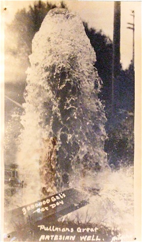
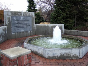
Thus, when shallow wells were dug in Pullman in the late 1800s, there were many artesian wells. There is a working replica of one of the wells at the NW corner of Olsen and Kamiaken, and there are pictures on the walls of the Old Pufferbelly Depot a short walk away.
With development has come increasing water extraction from the Grande Ronde aquifers. If surface water was able to recharge these aquifers at a rate equal to extraction, this would not be a problem. But it is not, and water levels in the deep wells serving WSU and Pullman have been dropping 1-3 feet per year for decades, and it has now been shown that recharge rate is very small, and that pumping greatly exceeds recharge.
The slow recharge is probably primarily due to two geologic features: the loess cap and the interbeds. The loess is formed from a fine dust and is thick enough in most places that water cannot permeate it and thus cannot enter the very permeable basalt.
Substantial clay layers in the interbeds and the Vantage Horizon also significantly impede the entry of groundwater into the basalt. A recently completed study east and north of Moscow illustrated this effect very clearly in this area.
Next: Water sustainability at WSU?

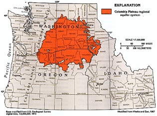
Columbia Plateau regional aquifer system -- a large approximately circular basalt system underlain primarily by Miocene basaltic rocks. (Source: Ground Water Atlas of the United States: Idaho, Oregon, Washington, USGS, figure 69.) Click on map to enlarge.
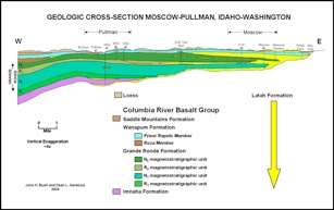
A regional geology cross section through Pullman and Moscow (Bush and Garwood) from 2002-2005 Palouse Ground Water Basin Water Use Report, by Steve Robischon for the Palouse Basin Aquifer Committee, October 2006. Click map to enlarge.
The red line delineates the working boundary for the Palouse Grande Ronde Ground Water Basin. Grande Ronde groundwater is the is the sole drinking water supply for the communities or Pullman and Moscow. Click map to enlarge.
Source: 2002-2005 Palouse Ground Water Basin Water Use Report, Steve Robischon, prepared for the Palouse Basin Aquifer Committee, October 2006
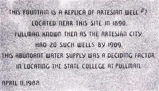
Pullman -- “the Artesian City” -- had 20 artesian wells. The abundant supply of water was a deciding factor in locating the state college at Pullman. The artesian wells are long gone, and now replicated by a fountain in downtown Pullman.
Click on maps to enlarge.